Mother Maps of the Commonwealth: Mapping Virginia in the Age of Enlightenment
Virginia’s physical description and spatial dimensions have changed several times in its four-hundred-year history, as documented in manuscript and published maps of the colony and commonwealth. The first depictions of the Chesapeake Bay, eastern North Carolina and tidewater Virginia were presented to the western world in 1590 when Theodore de Bry engraved John White’s manuscript map of Virginia in the first volume of his multi-volume atlas, America. Twenty-two years later Captain John Smith’s (1580-1631) Virginia Discovered and Discribed was published, and his accurate and detailed depiction of tidewater Virginia was widely successful, it was copied, mimicked, and plagiarized through the eighteenth century. Smith’s Virginia was the first “mother map” of Virginia, the first prototype of England’s successful colony. Not until 1673 was a better map published. Czech immigrant Augustine Herrman (1621-1686) spent ten years researching and drafting Virginia and Maryland as it is Planted in the Year 1670 and this map (and chart) replaced Smith’s as the prototype map of the region, and it was not superseded until 1751 when Virginia surveyors Joshua Fry (ca. 1700-1754) and Peter Jefferson (1708-1757) submitted their manuscript map of the colony to acting governor Lewis Burwell.[1] A Map of the Most Inhabited Parts of Virginia (1753) was the most important map of Virginia published in the eighteenth century. It served as source material for Lewis Evan’s Map of the Middle British Colonies (1755), John Mitchell’s Map of the British Colonies in North America (1755) and Thomas Jefferson’s A Map of the Albemarle Sound (1787). Several French mapmakers engraved and published derivatives of it, also.
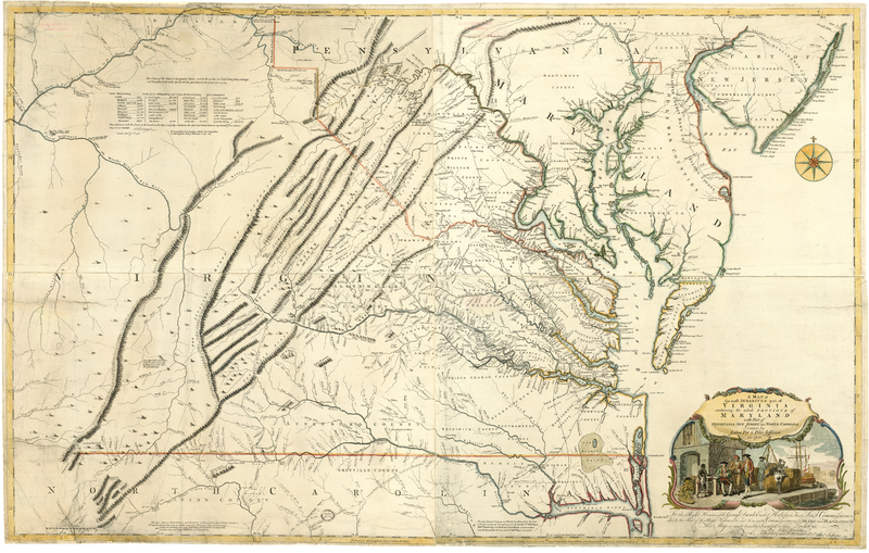
A Map of the Most Inhabited Part of Virginia Containing the Whole Province of Maryland : with Part of Pensilvania, New Jersey and North Carolina
Fry, Joshua, Peter Jefferson, and Thomas Jefferys. A Map of the Most Inhabited Part of Virginia Containing the Whole Province of Maryland : with Part of Pensilvania, New Jersey and North Carolina. London: ... Publish’d according to Act of Parliament by Thos. Jefferys, geographer to His Royal Highness the Prince of Wales at the corner of St. Martins Lane, Charing Cross, London, 1755. https://lva.primo.exlibrisgroup.com/permalink/01LVA_INST/altrmk/alma990015614860205756
This “mother map” was decommissioned when Bishop James Madison (1749-1812) oversaw the drafting, engraving and publication of A Map of Virginia in the first decade of the nineteenth century. Bishop Madison’s map served as an important reference during the War of 1812, was the muse for several map publishers, and was the most important map for the commonwealth until A Map of Virginia was endorsed and supported by Virginia’s General Assembly in 1826.
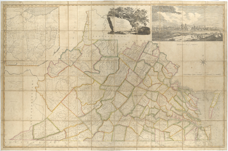
A Map of Virginia formed from Actual Surveys, and the Latest as well as the Most Accurate Observations
Madison, Bishop James. A Map of Virginia formed from Actual Surveys, and the Latest as well as the Most Accurate Observations. State One. Richmond, Virginia, 1807. Map Collection, Library of Virginia, Richmond, Virginia, USA. https://lva.primo.exlibrisgroup.com/permalink/01LVA_INST/altrmk/alma990016112300205756
Virginia’s Enlightenment era “mother maps” emerged in an “age of reconnaissance and nation-statehood and were compiled in languages that everyone could read and participate in: surveyors, sedentary map engravers, politicians who were also spatial architects, merchants, landscape designers and urban planners.”[2] They were birthed by actively engaged surveyors who incorporated the following data: population information, topographical features, spatial coordinates and state and local boundaries. Approximately fifty years separate Bishop Madison’s Map of Virginia from Fry and Jefferson’s Map of the Most Inhabited Parts of Virginia and significant events occurred during this time span. Who contributed to each’s creation? How do the two differ? How do each convey an enlightened Virginia?
[1] Augustine Herrman worked on his map of Maryland and Virginia for ten years; he was a jack of all trades – a diplomat, trader, surveyor, and merchant. For more information about Augustine Herrman please see Christian Koot, A Biography of a Map in Motion: Augustine Herrman’s Chesapeake (New York: New York University Press, 2018).
[2] Martin Bruckner, The Social Life of Maps in America 1750 – 1860 (Chapel Hill: University of North Carolina Press, 2017), 3.