A Map of the Colony?
Virginians moving west encouraged the laying of the boundary line between North Carolina and Virginia in 1729. The General Assembly was grappling with its boundary with the Fairfax Proprietary lands, also. Lieutenant Governor William Gooch (1681-1751) needed a map of the colony that reflected these changes. William Mayo (d. 1744), an experienced surveyor, and mapmaker who immigrated to Virginia in 1723, who had helped establish the boundary between Virginia and North Carolina in 1729, and who had a reputation for mapping large areas, having mapped Barbados, was approached by Lieutenant Governor Gooch to map the colony. In 1731 Lieutenant Governor Gooch requested that he “make a map of the country, not exact, but the best that could be drawn with little expense.”[1] This manuscript map, A General Map of the Known and Inhabited Parts of Virginia, correctly depicted Virginia’s boundary with North Carolina, the new piedmont ccounties, and the drainage system of the Shenandoah Valley.[2] Lieutenant Governor Gooch sent this to the Board of Trade and Plantations but they archived it. It was clear to many Virginians that a new and updated map of the colony reflecting the new counties and boundaries and the colony’s rich river system was needed.
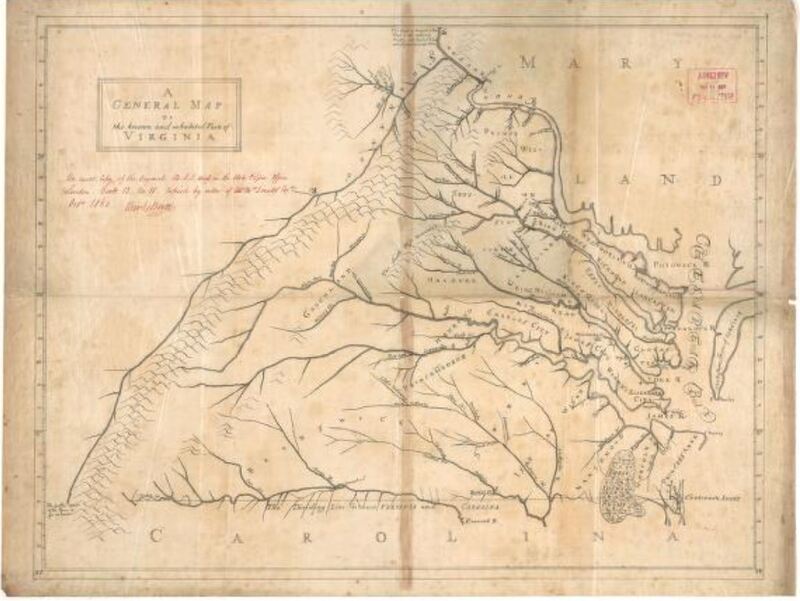
A General Map of the Known and Inhabited Parts of Virginia
Mayo, William, Charles Booth, A. W. McDonald, William Gooch, and Fairfax Harrison. A General Map of the Known and Inhabited Parts of Virginia. 1860. Map Collection, Library of Virginia, Richmond, Virginia, USA.
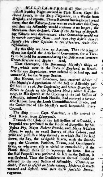
Surveyors William Mayo, Joshua Fry and Robert Brooke petitioned Virginia’s General Assembly in 1739 for “financial support for publication of a badly needed accurate map of the entire colony.”[3] Lieutenant Governor Gooch supported the venture as did the editors of Williamsburg’s Virginia Gazette (Williamsburg was the capitol of Virginia until 1780).[4] The Virginia General Assembly declined their petition. It was not until 1751 that Joshua Fry and Peter Jefferson were asked to compile a map of the colony with this critical information as the French were encroaching on British claimed lands. Why did acting Governor Lewis Burwell approach Fry and Jefferson for this task? Both were practiced surveyors who had surveyed patent lands in Albemarle and Goochland Counties, had participated in establishing the boundary lines between crown lands and the Fairfax Proprietary in 1746 and in extending the Virginia boundary line with North Carolina further west in 1749. Also, it is very likely that both had been trained by the highly regarded William Mayo.[6] The geodetic information needed for an improved map of the colony was located at the local county level; an abundant amount of information could be gleaned from Virginia’s surveyors. Fry and Jefferson had experience and a manuscript map by Mayo on which to base their manuscript map of the colony.
[1] Sarah S. Hughes, Surveyors and Statesmen: Land Measuring in Colonial Virginia (Richmond, Va.: The Virginia Surveyors Foundation, Ltd. And The Virginia Association of Surveyors, Ltd., 1979), 86.
[2] William Mayo, Charles Booth, A. W. McDonald, William Gooch, and Fairfax Harrison. “A General Map of the Known and Inhabited Parts of Virginia”, 1860. Library of Virginia Map Collection, G3881.F1 1731 .M3 1860, https://lva.primo.exlibrisgroup.com/permalink/01LVA_INST/altrmk/alma990015749530205756.
[3] Sarah S. Hughes, Surveyors and Statesmen, 86.
[4 Virginia Gazette, Article, January 5, 1739, p. 4.
[5] Virginia. General Assembly. House of Burgesses, H. R. (Henry Read) McIlwaine, and Virginia State Library. Journals of the House of Burgesses of Virginia, 1727-1734, 1736-1740. Richmond, Va: [The Colonial Press, E. Waddey Co.], 1910, p. 379, 404.
[6] Sarah S. Hughes, Surveyors and Statesmen, 85-87.