How Popular was the Fry and Jefferson Map of Virginia?
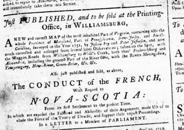
Just Published and To Be Sold at the Printing Office, Williamsburg Virginia
Advertisement for A Map of the Most Inhabited Parts of Virginia. Virginia Gazette. April, 1755.
Advertisements for A Map of the Most Inhabited Parts of Virginia appeared in several colonial newspapers, it was advertised in the Virginia Gazette and the Pennsylvania Gazette.[1] This suggests that Fry and Jefferson’s work was popular with colonial leaders and the public, its content reaching far beyond the offices of the Board of Trade and Plantations to the dining rooms of the elite and to the local tavern’s wall. Their product was an artifact used by everyone.[2] The map’s plates changed hands several times and it was published in eight states before the copperplates were retired. The firm of Laurie and Whittle issued the last known copies in the 1790s; they had purchased the plates from Robert Sayers and J. Bennett, who had published Fry and Jefferson’s map in the American Atlas, a compilation of maps engraved and sold by famed London map publisher Thomas Jefferys.
Another indicator of the map’s success is its use as a reference or content source for other period maps. Lewis Evans cites the Fry and Jefferson map as one of his sources for his A General Map of the Middle British Colonies.[3] John Mitchell incorporated information as evidenced by the location of the Fairfax Proprietary boundary line and the colony’s road system in his monumental work Map of the British Colonies in North America.[4] And it was copied by the French.
Geographical, historical, political, philosophical and mechanical essays. The first, containing an analysis of a general map of the middle British colonies in America; and of the country of the confederate Indians: a description of the face of the country; the boundaries of the confederates; and the maritime and inland navigations of the several rivers and lakes contained therein
Evans, Lewis. Geographical, historical, political, philosophical and mechanical essays... Philadelphia: Printed by B. Franklin, and D. Hall., MDCCLV. [1755], Early American Imprints, Series 1, no. 7412 (filmed), https://docs.newsbank.com.
From Paris the well-known and prolific family firm of Robert de Vaugondy (fl. 1731–1778) published in 1755 Carte la Virginie et du Mariland. By reducing content and word size the firm was able to limit the map to one sheet. Map scholars think that earlier states of this map were based upon the first state of Fry and Jefferson’s map because material is missing from the western sections, there is an absence of roads, and a lack of some eastern Virginia placenames. Ironically, country west of the Allegheny Mountains is labeled “Louisiane.”[5]
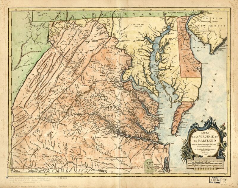
Carte de la Virginie et du Maryland
Robert de Vaugondy, Didier, Joshua Fry, Peter Jefferson, and Elisabeth Haussard. Carte de la Virginie et du Maryland. A Paris: Chez les auteurs, Quay de l’Horloge du Palais, Boudet Libraire Imprimeur du Roi, rue St. Jacques, 1757. Map Collection, Library of Virginia, Richmond, Virginia, USA. https://lva.primo.exlibrisgroup.com/permalink/01LVA_INST/altrmk/alma990015775040205756
Paris publisher Georges-Louis Le Rouge (ca. 1710 - ca. 1790) issued two atlases in 1778 that were originally published by the London firm of Jefferys and Faden (fl. 1773). His Atlas Amériquain included the second edition of the Fry and Jefferson map published in Paris as plate number 18 and titled Virginie, Mariland en 2 feuilles par Fry et Jefferson Traduit. By including an inset panel with the western parts of the colony, Le Rouge reduced the four-sheet map to two.[6]
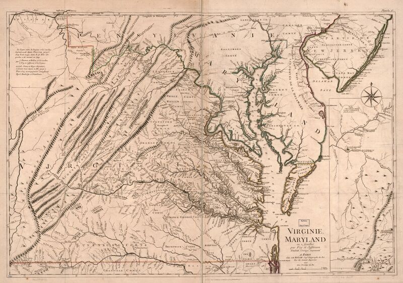
Virginie, Maryland en 2 feuilles par Fry et Jefferson.
Le Rouge, Georges-Louis, Joshua Fry, and Peter Jefferson. Virginie, Maryland en 2 feuilles par Fry et Jefferson . A Paris: chez Le Rouge, 1778. Map Collection, Library of Virginia, Richmond, Virginia, USA. https://lva.primo.exlibrisgroup.com/permalink/01LVA_INST/altrmk/alma990015793430205756
It was sought after during the American Revolutionary War. Copies of the maps in English were scarce by 1779 when the Virginia General Assembly assembled three people to procure maps of the state, Thomas Jefferson recorded that copies of Fry and Jefferson’s map were hard to find.
_____________________________________________
[1] Virginia Gazette, Advertisement, April 11, 1755, p. 3; Pennsylvania Gazette, Advertisement, October 21, 1756; Pennsylvania Gazette, Advertisement, November 4, 1756; South Carolina and American General Gazette, Advertisement, March 30, 1772, p. 2-4.
[2] The maps appear in wills and inventories. See Stafford County Virginia Will Book O, 1748-1763, “Inventory and Appraisal for the Estate of Reverend John Moncure,” October 12, 1765, p. 498.
[3] Lewis Evans, Geographical, historical, political, philosophical and mechanical essays. The first, containing an analysis of a general map of the middle British colonies in America; and of the country of the confederate Indians: a description of the face of the country; the boundaries of the confederates; and the maritime and inland navigations of the several rivers and lakes contained therein, Philadelphia: Printed by B. Franklin, and D. Hall., MDCCLV. [1755], Early American Imprints, Series 1, no. 7412 (filmed), https://docs.newsbank.com/openurl?ctx_ver=z39.88-2004&rft_id=info:sid/iw.newsbank.com:EAIX
&rft_val_format=info: ofi/fmt:kev:mtx:ctx&rft_dat=0F2FD4B85116BD98&svc_dat=Evans:eaidoc&req_dat=0D7AB4CAB745C82A.
[4] John Mitchell, Thomas Kitchin, and Andrew Millar. A map of the British and French dominions in North America, with the roads, distances, limits, and extent of the settlements, humbly inscribed to the Right Honourable the Earl of Halifax, and the other Right Honourable the Lords Commissioners for Trade & Plantations, [London; Sold by And: Millar i.e. 1757, 1757] Map. https://www.loc.gov/item/74693175/.
[5] Cassandra Farrell, From Williamsburg to Wills’s Creek: The Fry-Jefferson Map of Virginia (Richmond, Va.: Library of Virginia, 2009).
[6] Ibid.