Bishop Madison’s Map of the Commonwealth of Virginia
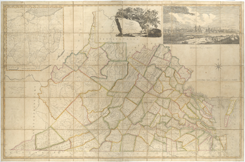
A Map of Virginia formed from Actual Surveys, and the Latest as well as the Most Accurate Observations
Madison, James, William Davis, and Fred Bossler. A Map of Virginia : Formed from Actual Surveys, and the Latest as Well as the Most Accurate Observations. Richmond: By the Proprietors, 1807. Map Collection, Library of Virginia, Richmond, Virginia, USA. https://lva.primo.exlibrisgroup.com/permalink/01LVA_INST/altrmk/alma990016112300205756
Fifty-four years passed between the publication of A Map of the Most Inhabited Parts of Virginia and Bishop James Madison’s Map of Virginia. The intervening years witnessed significant changes as England’s colonies emerged as united independent states separate from and equal to the British Empire. Map publishing changed, too.
Between 1790 and 1810 the first full-time American map publishers emerged and adopted a business model like the European framework. Communications between the researcher, draftsman, engraver, and printer were centralized and access to map archives were coordinated from one place; Philadelphia became the hub of map communication and publication. Between 1800 and 1840 a domestic map trade emerged as demand rose for accurate national, state and city maps.[1] They were of indigenous production based upon plats and surveys compiled by local surveyors. The maps were then drafted by artists and engraved by engravers living in Philadelphia or locally. This was a significant and important development in early American cartography; all processes involved in making a map were taking place in the United States of America.
This rise in indigenous mapping occurred for many reasons: exploration, the exploitation of natural resources, rising literary and mobility rates, nationalism, war, and western settlement. They were necessary tools as governments administered their respective states. Ironically, these early statehood maps were produced by private means and not by public funding. Most were drawn at a moderate scale, were designed to be wall maps that showed county and township boundaries, county seats, towns and villages, roads, and waterways. The first state map published for a southern state in the post-revolutionary era was Bishop Madison’s map of Virginia.
Bishop Madison recognized that an updated map of the commonwealth was desperately needed. He was an enlightened American, a man of many talents, who was a mathematician, minister, surveyor, and president of the College of William and Mary.[2] Since the map was completed long before many of its pre-1865 sources were destroyed by fire in April 1865, it is very plausible that Madison had access to state-boundary surveys, local county and city surveys that are no longer extant. Newspaper advertisements for A Map of Virginia as well as the map’s complete title, emphasize its foundation upon indigenous materials. Another mother map of Virginia was born in 1807.
[1] Martin Bruckner, The Social Life of Maps in America 1750 – 1860 (Chapel Hill: University of North Carolina Press, 2017), 219.
[2] In 1779 he had been chosen by the General Assembly to determine the boundary line between Virginia and Pennsylvania. See Virginia and William Waller Hening, “Agreement of Commissioners for Southern and Western Boundary of Pennsylvania,” The Statutes At Large: Being a Collection of All the Laws of Virginia, From the First Session of the Legislature, In the Year 1619, Vol. 10, (Richmond: Printed by and for Samuel Pleasants, junior, printer to the commonwealth, 1809-1823), 583.