Advertising the Map
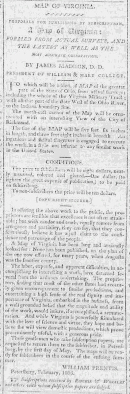
Bishop Madison and William Prentis (ca. 1740 - ca. 1824), editor, and proprietor of the Petersburg Intelligencer, began advertising and seeking subscriptions for A Map of Virginia two years before it was published. Prentis submitted a letter for publication in the February 5, 1805, issue of the Richmond Enquirer, announcing that a manuscript copy of the map had been submitted to the Virginia General Assembly for inspection.[1] This was followed by Bishop Madison’s statement on the map’s importance. He identified the sources for the map’s data; it included current coordinate information, latitude, and longitude degrees for several important places, the transmountain and middle parts of the state reflected current survey work as did the state and county boundaries. River courses, mountain bearings and completed state boundaries were shown accurately. An insert of the Virginia Military Tract in Ohio would be included. The manuscript map’s dimensions were 5 feet 6 inches in length and 3 feet by 8 inches in breadth; A Map of Virginia was intended to be a wall map, to accurately promote geographical knowledge.[2]
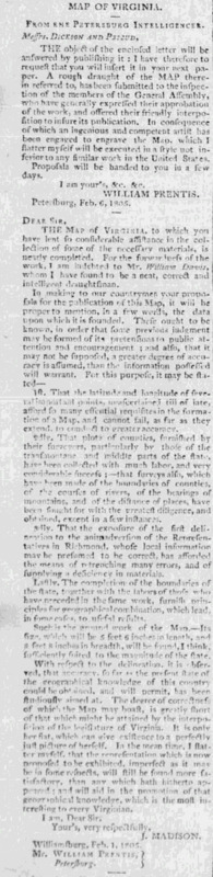
Like many early nineteenth century map publishers, Madison and Prentis had to raise their “own business capital, use their own personal funds, bank loans and discounted subscriptions to publish their map of Virginia.[3] Notices regarding the map’s publication status appeared in newspapers along the Atlantic seaboard.[4] Subscribers were promised a two-dollar discount from the ten-dollar asking price, their copy would be mounted, colored and glazed. In March 1805 Madison and Prentis believed that the map would be completed by that summer.[5]
[Call for Subscriptions for Madison Map of Virginia]
"A Map of Virginia." Richmond Enquirer. March 15, 1805. https://newspaperarchive.com/richmond-enquirer-mar-15-1805-p-4/
[1] This announcement followed an insert in the December 20, 1804, issue announcing that it was to be given to the General Assembly in two to three weeks. Richmond Enquirer, “Map of Virginia” February 15, 1805, p. 4; Richmond Enquirer, “Map of Virginia, December 20, 1804, p.3.
[2] Ibid.
[3] Martin Bruckner, The Social Life of Maps in America 1750 – 1860 (Chapel Hill: University of North Carolina Press, 2017), 44.
[4] “Virginia,” The Albany Register, January 22, 1805; “Map of Virginia,” The Independent Chronicler, January 3, 1805.
[5] Richmond Enquirer, A Map of Virginia, March 15, 1805, p. 4. https://newspaperarchive.com/richmond-enquirer-mar-15-1805-p-4/