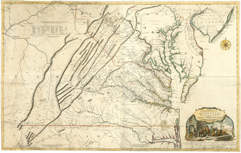
A Map of the Most Inhabited Parts of Virginia
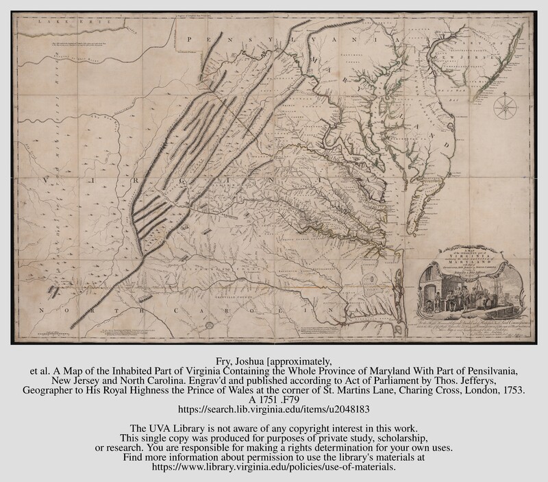
A Map of the Inhabited Part of Virginia Containing the Whole Province of Maryland With Part of Pensilvania, New Jersey and North Carolina
Fry, Joshua and Peter Jefferson. A Map of the Inhabited Part of Virginia Containing the Whole Province of Maryland With Part of Pensilvania, New Jersey and North Carolina. London: Thomas Jeffreys, 1753?. Special Collections, University of Virginia, Charlottesville, Virginia.
In 1751 acting Governor Burwell forwarded to the Board of Trade and Plantations Fry and Jefferson’s manuscript map of Virginia. Pleased with its information they forwarded it to map publisher Thomas Jefferys who engraved A Map of the Inhabited Part of Virginia containing the whole Province of Maryland with Part of Pennsilvania, New Jersey and North Carolina drawn by Joshua Fry and Peter Jefferson on four copperplates.
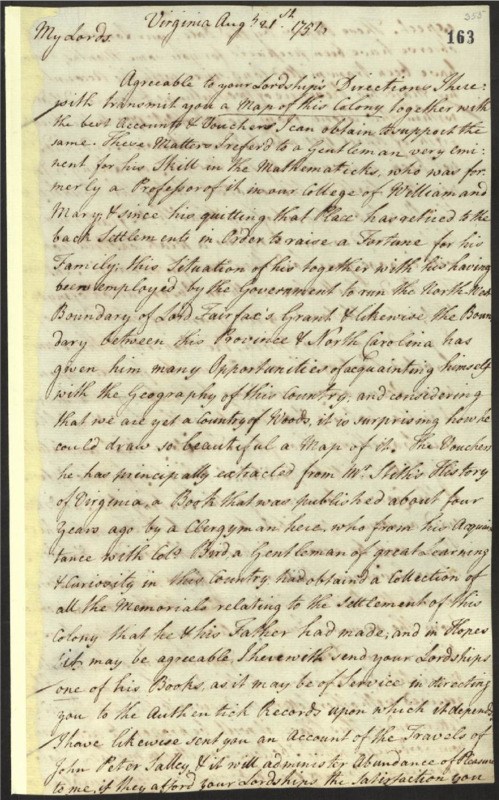
Letter from Lewis Burwell to the Board of Trade and Plantations.
"Lewis Burwell to Board of Trade and Plantations." Letter. August 21, 1751. "Letters from Lewis Burwell Correspondence." The National Archives, Kew. Co 5/1327 Part one 1750/11/24-1751/1/17.
Charles Grignion engraved it and the cartouche is striking in its display of Virginia’s slave and tobacco cultures, simultaneously describing a wealthy colony with stone tobacco warehouses, busy harbors, and wealthy white men dressed in the latest gentleman’s fashion being served by the enslaved who are also moving the very large hogsheads of tobacco. (The colonists were prevented from sustained production of maps because of regulations and an infrastructure was not in place at the colonial level for large scale map production.) The cartouche is surrounded by a delicate baroque border. The first draft incorporated the lower edges of Lake Erie and the colony’s watershed is intricately detailed. Counties are named but borders for each were not included. The Appalachian Mountain range is correctly delineated and an immense amount of information about the backcountry is shown. Significant mountains are identified as are large tracts of land – the recently determined Fairfax Proprietary and Virginia-North Carolina boundary lines are included. The map teems with placenames, especially the names of the large plantations along Virginia’s waterways, providing the British and the French with important information about Virginia’s tobacco trade and her most important planters.
Fry and Jefferson were able to access George Washington’s and Christopher Gist’s notes and journal “from their travels as emissaries to the French outpost in Ohio County in 1753.”[1] They significantly revised their map to incorporate Washington and Gist’s findings and Jeffery’s refashioned the copperplates to incorporate these changes which are reflected in the map’s second state that was published in 1754. Captain John Dalrymple supplied a scale of distances that were placed in the upper left quadrant.
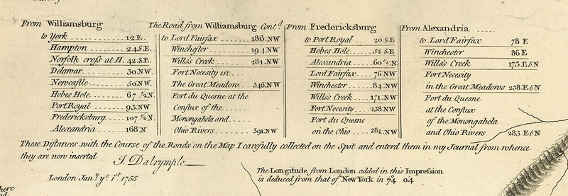
Dalrymple Table.
Dalrymple, John. "Dalrymple Table." A Map of the Most Inhabited Parts of Virginia. London: Thomas Jefferys, 1755. Map Collection. Library of Virginia, Richmond, Virginia. https://lva.primo.exlibrisgroup.com/permalink/01LVA_INST/altrmk/alma990015614860205756
The significantly altered map included a new title, A Map of the Most Inhabited Parts of Virginia and new information about western North Carolina, eastern Tennessee, and Kentucky. They drew the western limits of Maryland with “equal strength” and the Great Wagon Road is present as are Virginia’s major roads, the footprints for several present-day roadways are evident.[2] The westerly flow of the Holston, New, Green Briar, Monongahela and Youghiogheny Rivers are clear and indicative of the westerly migration taking place in the colony. The map does not end, viewers are left with the impression that Virginia’s boundaries extend beyond what can be shown on four copperplate sheets. Numerous plantation owners are listed and “the map represents Virginia’s social topography; it is a spatial representation of kinship networks and centers of political power.”[3] The Iroquois and Delaware Tribes ceded lands south of the Ohio River to the colony in Treaty of Logstown (1752) and this is reflected in Fry and Jefferson’s maps.[4]
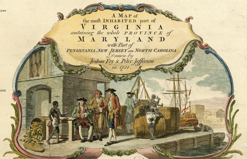
[Cartouche from the Fry and Jefferson Map of Virginia]
Cartouche. Fry, Joshua, Peter Jefferson, and Thomas Jefferys. A Map of the Most Inhabited Part of Virginia Containing the Whole Province of Maryland : with Part of Pensilvania, New Jersey and North Carolina . London: ... Publish’d according to Act of Parliament by Thos. Jefferys, geographer to His Royal Highness the Prince of Wales at the corner of St. Martins Lane, Charing Cross, London, 1755. Map Collection, Library of Virginia, Richmond, Virginia. https://lva.primo.exlibrisgroup.com/permalink/01LVA_INST/altrmk/alma990015614860205756
Simultaneously, A Map of the Most Inhabited Parts of Virginia represented one of Great Britain’s prized possessions, projected order, peace, prosperity, and unity; the British Empire parceled lands to colonists willing to cultivate the frontier and, in that process, facilitate the removal of indigenous peoples as they surveilled local colonial cultures. And it was a commercial good and a social medium, an artifact of empire and a projection of the idea of Virginia.[5]
A Map of the Most Inhabited Part of Virginia Containing the Whole Province of Maryland : with Part of Pensilvania, New Jersey and North Carolina
Fry, Joshua, Peter Jefferson, and Thomas Jefferys. A Map of the Most Inhabited Part of Virginia Containing the Whole Province of Maryland : with Part of Pensilvania, New Jersey and North Carolina. London: ... Publish’d according to Act of Parliament by Thos. Jefferys, geographer to His Royal Highness the Prince of Wales at the corner of St. Martins Lane, Charing Cross, London, 1755. Map Collection, Library of Virginia, Richmond, Virginia. https://lva.primo.exlibrisgroup.com/permalink/01LVA_INST/altrmk/alma990015614860205756
[1] Richard Stephenson and Marianne McKee, eds., Virginia in Maps: Four Centuries of Settlement, Growth and Development, (Richmond: Library of Virginia, 1999), 54.
[2] Stephenson and McKee, 54-55; Fry, Joshua, Approximately, Peter Jefferson, and Thomas Jefferys. A map of the most inhabited part of Virginia containing the whole province of Maryland: with part of Pensilvania, New Jersey and North Carolina. [London, Thos. Jefferys, 1755] Map. https://www.loc.gov/item/74693089/.
[3] Martin Bruckner, The Social Life of Maps in America 1750 – 1860 (Chapel Hill: University of North Carolina Press, 2017), 165.
[4 Seymour Schwartz and Ralph Ehrenberg, The Mapping of North America (New York: Harry N. Abrams, Incorporated, 1980), 157. This cession of lands to Virginia in the Treaty of Logstown allowed the Ohio Land Company to begin building along the Monongahela River.
[5] Bruckner, Social Life of Maps, 5-10.